Photographie et Vidéo par Drone
Ecosystems and regeneration evaluation and monitoring
Ecosystems and regeneration evaluation and monitoring
Ecosystems and regeneration evaluation and monitoring
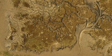
High-resolution, data-rich insights that support ecosystem assessment, regeneration planning, and long-term environmental monitoring. Using advanced aerial imaging, multispectral and thermal sensors, and precise geolocation, we capture detailed information on vegetation health, soil conditions, water distribution, and habitat changes. This allows organizations, land managers, and conservation teams to detect early signs of ecosystem stress, measure the effectiveness of regeneration efforts, and create accurate, repeatable records over time. By combining efficiency with scientific accuracy, our drone-based evaluations help guide smarter decision-making and contribute to healthier, more resilient natural landscapes.
Monitoring of infrastructures
Ecosystems and regeneration evaluation and monitoring
Ecosystems and regeneration evaluation and monitoring

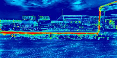
Efficient and reliable monitoring of critical infrastructures, delivering high-resolution aerial data that enhances visibility, safety, and decision-making. Using advanced sensors and real-time imaging, we can inspect structures such as bridges, power lines, pipelines, and construction sites with precision—without the risks or downtime associated with manual inspections. Our drones capture detailed visuals from multiple angles, enabling early detection of wear, damage, or potential hazards. This proactive approach helps reduce maintenance costs, improve operational efficiency, and ensure long-term structural integrity for your assets.
Inspection of services
Ecosystems and regeneration evaluation and monitoring
Inspection of services
Fast, accurate, and cost-effective assessments of hard-to-reach areas, helping clients improve safety and efficiency across their operations. Using high-resolution imaging, thermal sensors, and advanced flight capabilities, we capture detailed visual and data-driven insights without the need for scaffolding, lifts, or manual inspections. Whether you require structural assessments, asset monitoring, or routine maintenance checks, our drones deliver precise results that support informed decision-making and minimize downtime.